- ES Español (Latinoamérica)

- EN English

3.65. CE2C6 Territorial Planning (Mandatory)
- Semester: 9th Sem. Credits: 3
- Hour of this course: Theory: 2 hours; Laboratory: 2 hours;
- Syllabus:
 Español (Latinoamérica)
 English
- Prerrequisites:
- 160Cr
- ES Español (Latinoamérica)
- EN English
3.65.1. Justification Back to top
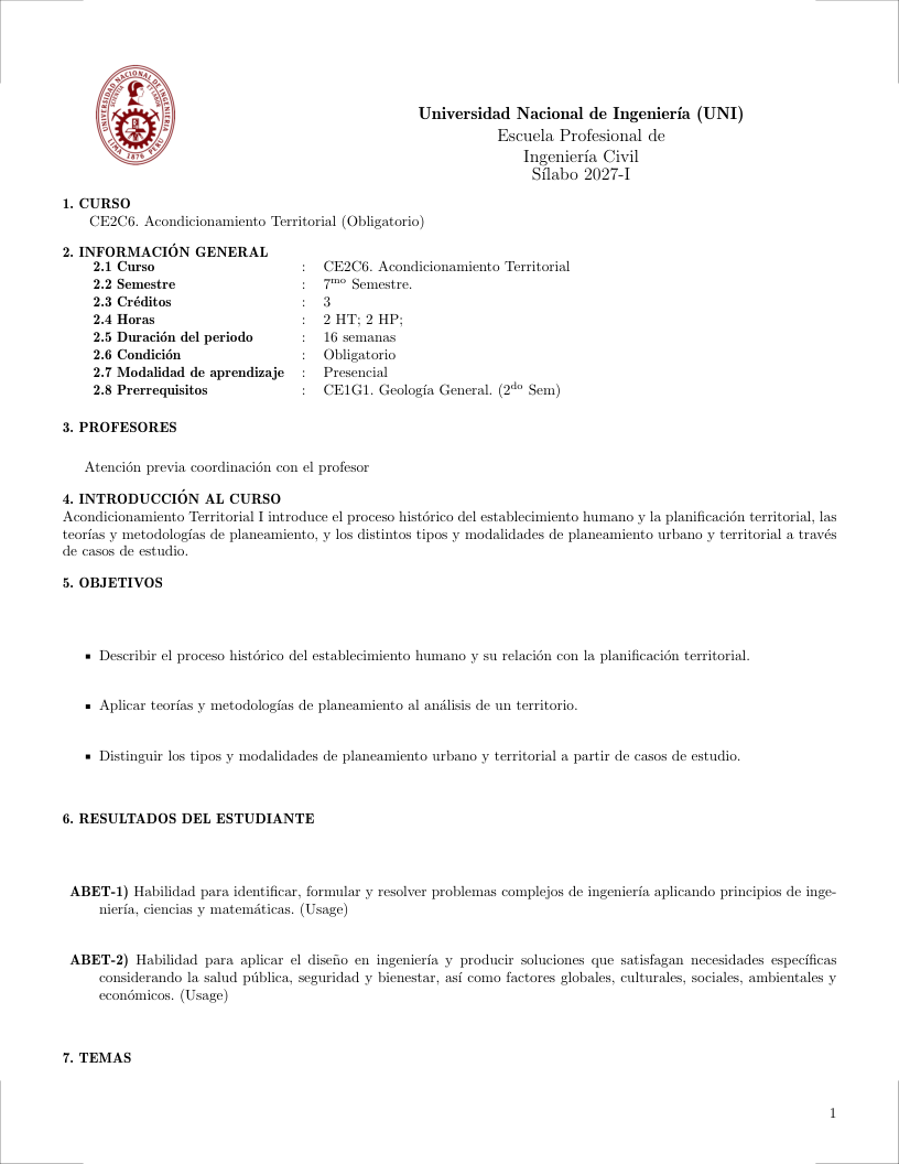
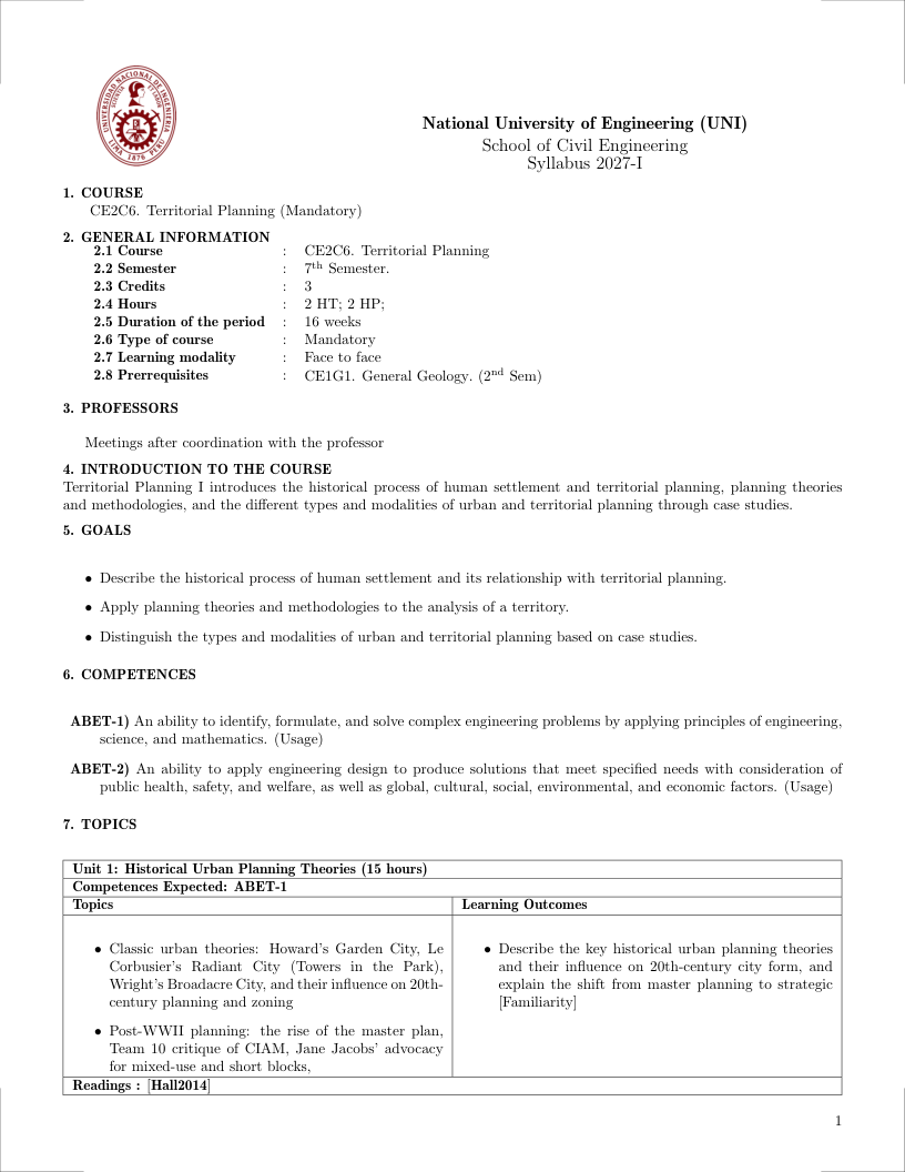
Territorial Planning I introduces the historical process of human settlement and territorial planning, planning theories and methodologies, and the different types and modalities of urban and territorial planning through case studies. It also covers the Peruvian regulatory framework and instruments for territorial planning and land-use ordering (RATDUS, PAT, PDU, zoning, and the National Territorial Planning System), so students can apply international planning theory within the legal and institutional context in which they will practice.
- ES Español (Latinoamérica)
- EN English
3.65.2. Generales Goals Back to top
- Describe the historical process of human settlement and its relationship with territorial planning.
- Apply planning theories and methodologies to the analysis of a territory.
- Distinguish the types and modalities of urban and territorial planning based on case studies.
- Apply the Peruvian regulatory framework and instruments for territorial planning and land-use ordering.
- ES Español (Latinoamérica)
- EN English
3.65.3. Contribution to Outcomes Back to top
- ABET-1) An ability to identify, formulate, and solve complex engineering problems by applying principles of engineering, science, and mathematics. (Usage)
- ABET-2) An ability to apply engineering design to produce solutions that meet specified needs with consideration of public health, safety, and welfare, as well as global, cultural, social, environmental, and economic factors. (Usage)
- ES Español (Latinoamérica)
- EN English
3.65.4. Content Back to top
- ES Español (Latinoamérica)
- EN English
3.65.4.1. Historical Urban Planning Theories (15 hours) [Skills ABET-1] Back to top
Bibliography: (Hall and Tewdwr-Jones, 2014)
Topics
- Classic urban theories: Howard's Garden City, Le Corbusier's Radiant City (Towers in the Park), Wright's Broadacre City, and their influence on 20th-century planning and zoning
- Post-WWII planning: the rise of the master plan, Team 10 critique of CIAM, Jane Jacobs' advocacy for mixed-use and short blocks,
Learning Outcomes
- Describe the key historical urban planning theories and their influence on 20th-century city form, and explain the shift from master planning to strategic [Familiarity]
- ES Español (Latinoamérica)
- EN English
3.65.4.2. Contemporary Planning Methods and Theory (29 hours) [Skills ABET-1] Back to top
Bibliography: (Hall and Tewdwr-Jones, 2014)
Topics
- Planning methods: zoning (Euclidean, form-based, performance-based), master planning vs. strategic planning, public participation (charrettes, community workshops
- Smart growth and new urbanism: principles (transit-oriented development, walkability, mixed-income housing, urban growth boundaries), Andrés Duany's transect,
- Contemporary urban theory: Lefebvre's production of space, Harvey's right to the city, Sennett's open city, and the role of informality, participation,
- Integration of civil engineering technical constraints (structural, geotechnical, utility infrastructure, and transportation) into urban planning and architectural design frameworks; the collaborative role of civil engineers in multidisciplinary building and urban project teams
Learning Outcomes
- Apply a planning method - such as form-based coding or scenario planning - to a specific urban site, producing land use or built form regulations that align with stated policy [Usage]
- Evaluate a current urban plan or zoning code against contemporary planning principles (walkability, mixed-use, transit orientation, social equity), identifying strengths [Assessment]
- ES Español (Latinoamérica)
- EN English
3.65.4.3. Urban Design at Multiple Scales (12 hours) [Skills ABET-2] Back to top
Bibliography: (Hall and Tewdwr-Jones, 2014)
Topics
- Regional and city scale: transit corridors, green belts, growth boundaries, satellite towns, and the relationship between density
- Neighborhood scale: walkability (5-10 minute walking radius), mixed-use zoning, social infrastructure (schools, clinics, community centers), and the 20-minute neighborhood concept
- Block and street scale: block length for pedestrian permeability (80-120 m max), street section design (lane widths, sidewalks, bike lanes, street trees, furniture zone),
- Public space design: squares, plazas, parks, pocket parks, and streets as public space; William Whyte's elements of successful public space (sittable space, sun, food
- Urban design guidelines: building setbacks, height limits, architectural character, facade articulation, signage, lighting,
Learning Outcomes
- Describe the key design considerations at each urban scale - regional, neighborhood, block, street, and public space - [Familiarity]
- Develop a set of urban design guidelines for a specific neighborhood or street typology, integrating density, building height, block length, street section, [Usage]
- Evaluate an urban design project for its multi-scale coherence, assessing how well it integrates regional transit, neighborhood walkability, block permeability, street safety, [Assessment]
- ES Español (Latinoamérica)
- EN English
3.65.4.4. Peruvian Framework for Territorial Planning and Land-Use Ordering (8 hours) [Skills ABET-1] Back to top
Bibliography: (Ministerio de Vivienda, Construcción y Saneamiento del Perú, 2016; Centro Nacional de Planeamiento Estratégico (CEPLAN), 2016)
Topics
- Regulation on Territorial Planning and Sustainable Urban Development (RATDUS, Supreme Decree No. 022-2016-VIVIENDA): scope, principles, and classification of planning instruments
- Territorial Planning Plan (PAT) and Urban Development Plan (PDU): content, formulation process, and articulation between the provincial and district scales
- Zoning and land classification under Peruvian regulations: permitted uses, urban parameters, and compatibility
- National Territorial Planning System and CEPLAN's role in articulating territorial planning with development planning
- Incorporating disaster risk management and climate change into territorial planning instruments
Learning Outcomes
- Describe the hierarchy and content of Peru's territorial planning instruments (RATDUS, PAT, PDU) [Familiarity]
- Apply Peruvian zoning criteria and urban parameters to the analysis of a plot or urban sector [Usage]
- Explain the role of the National Territorial Planning System and CEPLAN in articulating territorial planning instruments [Familiarity]
- Evaluate whether a Territorial Planning Plan or Urban Development Plan adequately incorporates disaster risk management and climate change [Assessment]
- ES Español (Latinoamérica)
- EN English
3.65.5. Bibliography Back to top
Hall, P. and Tewdwr-Jones, M. (2014). Urban and Regional Planning. Routledge, 6th edition.
Ministerio de Vivienda, Construcción y Saneamiento del Perú (2016). Reglamento de acondicionamiento territorial y desarrollo urbano sostenible (ratdus). Decreto Supremo N. 022-2016-VIVIENDA.
Centro Nacional de Planeamiento Estratégico (CEPLAN) (2016). Lineamientos y guía metodológica para el ordenamiento territorial.