- ES Español (Latinoamérica)

- EN English

7.62. Highway Geometric Design (Mandatory)
- Semester: 9th Sem. Credits: 4
- Hour of this course: Theory: 3 hours; Practice: 2 hours;
- Syllabus:
- htmlonly
 Español (Latinoamérica)
 English
- Prerrequisites:
- CE2T1 Basic Geomatics (6th Sem)
- CE2T4 Transportation Engineering (8th Sem)
7.62.1. Justification ↑ Back to top
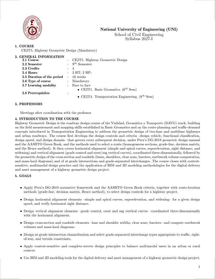
Highway Geometric Design is the roadway design course of the Vialidad, Geomática y Transporte (DAVG) track, building on the field measurement and mapping skills established in Basic Geomatics and on the route-planning and traffic-demand concepts introduced in Transportation Engineering to address the geometric design of two-lane and multilane highways and urban roadways. The course first develops the design controls and criteria –design vehicle, functional classification, design speed, and design domain– that govern every subsequent decision, under Peru's DG-2018 geometric design manual and the AASHTO Green Book, and the methods used to select a route (homogeneous sections, grade-line, decision matrix, and the Bruce method). It then covers horizontal alignment (simple and spiral curves, superelevation, sight distance, and widening) and vertical alignment (grade control and crest/sag vertical curves), coordinated three-dimensionally, followed by the geometric design of the cross section and roadside (lanes, shoulders, clear zone, barriers, earthwork volume computation, and mass-haul diagrams) and of at-grade intersections and grade-separated interchanges. The course closes with context-sensitive, multimodal design practice and the application of BIM and 3D modeling methodologies for the digital delivery and asset management of a highway geometric design project.
7.62.2. Generales Goals ↑ Back to top
- Apply Peru's DG-2018 normative framework and the AASHTO Green Book criteria, together with route-location methods (grade-line, decision matrix, Bruce method), to select design controls for a highway project.
- Design horizontal alignment elements –simple and spiral curves, superelevation, and widening– for a given design speed, and verify horizontal sight distance.
- Design vertical alignment elements –grade control, crest and sag vertical curves– coordinated three-dimensionally with the horizontal alignment.
- Design cross-section and roadside elements –lane and shoulder widths, clear zone, barriers– and compute earthwork volumes and mass-haul diagrams.
- Design at-grade intersection channelization and select grade-separated interchange types appropriate to traffic, right-of-way, and terrain constraints.
- Apply context-sensitive and complete-streets design principles to balance multimodal users in an urban or rural context.
- Use BIM and 3D modeling tools for the digital delivery and asset management of a highway geometric design project.
7.62.3. Contribution to Outcomes ↑ Back to top
- ABET-1) An ability to identify, formulate, and solve complex engineering problems by applying principles of engineering, science, and mathematics. (Usage)
- ABET-2) An ability to apply engineering design to produce solutions that meet specified needs with consideration of public health, safety, and welfare, as well as global, cultural, social, environmental, and economic factors. (Usage)
- ABET-6) An ability to develop and conduct appropriate experimentation, analyze and interpret data, and use engineering judgment to draw conclusions. (Usage)
7.62.4. Content ↑ Back to top
7.62.4.1. Design Controls and Criteria (14 hours) [Skills ABET-1] ↑ Back to top
Bibliography: (Ministerio de Transportes y Comunicaciones del Perú, 2018; AASHTO, 2018a)
Topics
- Design vehicle types and turning template characteristics
- Driver performance characteristics: perception-reaction time and eye/object height
- Functional classification of highways and streets and its relation to design criteria
- Design speed selection and its relationship to operating speed
- Design domain concept and flexible design criteria ranges
- Design exception process for substandard criteria
Learning Outcomes
- Select an appropriate design vehicle and apply its turning template to a layout [Familiarity]
- Apply driver performance parameters (perception-reaction time, eye/object height) in design computations [Usage]
- Determine the functional classification of a facility and the design criteria it implies [Assessment]
- Select a design speed consistent with context, function, and operating speed expectations [Assessment]
- Explain the design domain concept and its use in flexible design [Familiarity]
- Document a design exception for a criterion that cannot be met [Usage]
7.62.4.2. Horizontal Alignment Design (20 hours) [Skills ABET-2] ↑ Back to top
Bibliography: (AASHTO, 2018a; Garber and Hoel, 2019)
Topics
- Simple circular curve geometry and layout
- Spiral transition curves and their application
- Superelevation design, rates, and runoff/transition lengths
- Side friction factors and minimum radius determination
- Horizontal sight distance and sight obstructions on curves
- Compound and reverse curve design considerations
Learning Outcomes
- Design simple circular horizontal curves for a given design speed [Usage]
- Apply spiral transition curves where required by design speed and curvature [Assessment]
- Design superelevation rates and transition/runoff lengths for a horizontal curve [Assessment]
- Determine minimum curve radius from side friction and superelevation limits [Usage]
- Verify horizontal sight distance and identify sight obstructions along a curve [Assessment]
- Evaluate compound and reverse curve layouts against design guidance [Familiarity]
7.62.4.3. Vertical Alignment Design (12 hours) [Skills ABET-1,ABET-2] ↑ Back to top
Bibliography: (AASHTO, 2018a; Garber and Hoel, 2019)
Topics
- Maximum and minimum grade control and critical length of grade
- Crest vertical curve design for stopping sight distance
- Sag vertical curve design for headlight and comfort criteria
- Stopping sight distance computation and application
- Passing sight distance on two-lane highways
- Vertical clearance requirements at structures and underpasses
Learning Outcomes
- Apply grade control criteria including critical length of grade for trucks [Assessment]
- Design crest vertical curves satisfying stopping sight distance [Assessment]
- Design sag vertical curves satisfying headlight and comfort criteria [Assessment]
- Compute stopping sight distance for a given design speed and grade [Usage]
- Determine passing sight distance requirements on two-lane highways [Usage]
- Verify vertical clearance at structures against design standards [Familiarity]
7.62.4.4. Cross-Section Elements and Roadside Design (14 hours) [Skills ABET-2] ↑ Back to top
Bibliography: (AASHTO, 2018a; Garber and Hoel, 2019)
Topics
- Lane and shoulder width selection by functional class and context
- Median types, widths, and median barrier warrants
- Cross slope, superelevation transition, and drainage considerations
- Clear zone width determination and roadside hazard rating
- Roadside barrier selection, placement, and end treatments
- Sidewalk, bike lane, and buffer cross-section design
Learning Outcomes
- Select lane and shoulder widths appropriate to functional class and context [Usage]
- Determine median type, width, and barrier warrant for a given facility [Assessment]
- Explain cross slope and drainage requirements in cross-section design [Familiarity]
- Determine clear zone width from roadside hazard rating and design speed [Assessment]
- Select and place roadside barriers and end treatments [Usage]
- Design sidewalk, bike lane, and buffer cross-sections for a complete street [Assessment]
7.62.4.5. At-Grade Intersections and Interchanges (10 hours) [Skills ABET-2] ↑ Back to top
Bibliography: (AASHTO, 2018a; Garber and Hoel, 2019)
Topics
- At-grade intersection types and alignment/skew considerations
- Channelization and turning lane design (left/right turn lanes)
- Intersection sight distance and approach sight triangles
- Interchange types and selection criteria (diamond, cloverleaf, directional)
- Ramp geometric design and gore area treatment
- Weaving section geometry and auxiliary lane design
Learning Outcomes
- Select an at-grade intersection type and alignment appropriate to approach conditions [Assessment]
- Design channelization and turning lanes for an at-grade intersection [Usage]
- Verify intersection sight distance against approach sight triangle criteria [Usage]
- Select an interchange type appropriate to traffic, right-of-way, and terrain constraints [Assessment]
- Design ramp geometry and gore area treatments [Usage]
- Analyze weaving section geometry and auxiliary lane requirements [Assessment]
7.62.4.6. Context-Sensitive and Multimodal Design (8 hours) [Skills ABET-2] ↑ Back to top
Bibliography: (National Association of City Transportation Officials (NACTO), 2013; AASHTO, 2018a)
Topics
- Context-sensitive design process and stakeholder-based criteria flexibility
- Complete streets principles and multimodal accommodation
- Traffic calming elements for urban and residential streets
- Three-dimensional coordination of horizontal and vertical alignment
- Aesthetic and environmental considerations in geometric design
- Access management and driveway spacing criteria
Learning Outcomes
- Explain the context-sensitive design process and when design flexibility is appropriate [Familiarity]
- Apply complete streets principles to accommodate multiple travel modes [Usage]
- Select traffic calming elements appropriate to an urban or residential context [Assessment]
- Coordinate horizontal and vertical alignment for a three-dimensionally consistent design [Assessment]
- Consider aesthetic and environmental factors in geometric design decisions [Familiarity]
- Apply access management criteria to driveway and intersection spacing [Usage]
7.62.4.7. Building Information Modeling (BIM) for Digital Delivery and Asset Management (6 hours) [Skills ABET-6] ↑ Back to top
Bibliography: (Eastman et al., 2018)
Topics
- BIM concepts: dimensions (3D, 4D, 5D, 6D, 7D), LOD, and LOIN
- BIM authoring tools and parametric modeling techniques
- Model coordination, clash detection, and interference checking
- Collaboration platforms, Common Data Environments (CDE), and BIM execution plans
- BIM-based analysis: quantity takeoff, energy simulation, and structural analysis
- Digital twins and the connection between BIM and operational data
- Interoperability standards: IFC, COBie, and openBIM
- Asset information models (AIM) and BIM for facilities management (FM)
- Regulatory submission and automated code compliance checking
Learning Outcomes
- Define the different dimensions of BIM (3D-7D) and their associated information [Familiarity]
- Create a basic 3D parametric model of a structural framing system using BIM software [Usage]
- Perform a clash detection analysis between architectural and structural models [Assessment]
- Outline the key components of a BIM Execution Plan (BEP) [Familiarity]
- Extract a material quantity takeoff schedule from a BIM model [Usage]
- Explain the relationship between a BIM model and a digital twin for an asset [Familiarity]
- Export a BIM model using the IFC format to ensure interoperability [Usage]
- Develop an Asset Information Model (AIM) deliverable for handover to a facility manager [Assessment]
- Evaluate the potential of automated rule-checking for building code compliance [Assessment]
7.62.5. Bibliography ↑ Back to top
Ministerio de Transportes y Comunicaciones del Perú (2018). Manual de carreteras: Diseño geométrico (dg-2018). Technical report, Ministerio de Transportes y Comunicaciones.
AASHTO (2018a). A policy on geometric design of highways and streets. Technical report, American Association of State Highway and Transportation Officials.
Garber, N. J. and Hoel, L. A. (2019). Traffic and Highway Engineering. Cengage Learning, 6th edition.
National Association of City Transportation Officials (NACTO) (2013). Urban Street Design Guide. Island Press.
Eastman, C., Teicholz, P., Sacks, R., and Liston, K. (2018). BIM Handbook: A Guide to Building Information Modeling for Owners, Designers, Engineers, Contractors, and Facility Managers. Wiley, 3rd edition.